Maps of Australia

Political Map
This map shows us the state boundaries of Australia and the location of cities.
This map shows us the state boundaries of Australia and the location of cities.

Physical Map
This physical map shows the physical landscape features such as rivers, mountains, deserts. Areas that are green represent low elevations, while lighter coloured areas represent higher elevated ground.
This physical map shows the physical landscape features such as rivers, mountains, deserts. Areas that are green represent low elevations, while lighter coloured areas represent higher elevated ground.

Topographic Map
This map also shows physical landscape features, but shows elevation using contour lines instead of colours.
This map also shows physical landscape features, but shows elevation using contour lines instead of colours.
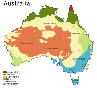
Climate Map
Shows us different climatic zones. We can easily visually compare the atmospheric conditions from desert, grassland, temperate, tropical or equatorial areas.
Shows us different climatic zones. We can easily visually compare the atmospheric conditions from desert, grassland, temperate, tropical or equatorial areas.

Rainfall Map
This rainfall map shows us the average rainfall in millimetres from 1900 to 2005. There is a key indicating different representations of different results. Here we can see that rainfall is more consistent near coastal areas than towards the centre, with an exception of parts of the Western Australian coast.
This rainfall map shows us the average rainfall in millimetres from 1900 to 2005. There is a key indicating different representations of different results. Here we can see that rainfall is more consistent near coastal areas than towards the centre, with an exception of parts of the Western Australian coast.

Economic/Resource Map
This shows the different natural resources present throughout Australia using abbreviations and different symbols as given in the key.
This shows the different natural resources present throughout Australia using abbreviations and different symbols as given in the key.

Thematic Map
A thematic map is one that focuses on a particular theme of an area. This thematic map shows us the vegetation around Australia. We can see the concentration of different plants in different habitats.
A thematic map is one that focuses on a particular theme of an area. This thematic map shows us the vegetation around Australia. We can see the concentration of different plants in different habitats.

Population Map
We can see the distribution of people around the nation. In this map we can see the amount of people per square km and how we are concentrated around major cities such as Sydney, Brisbane, Melbourne and Perth, and also near Cairns.
We can see the distribution of people around the nation. In this map we can see the amount of people per square km and how we are concentrated around major cities such as Sydney, Brisbane, Melbourne and Perth, and also near Cairns.
